
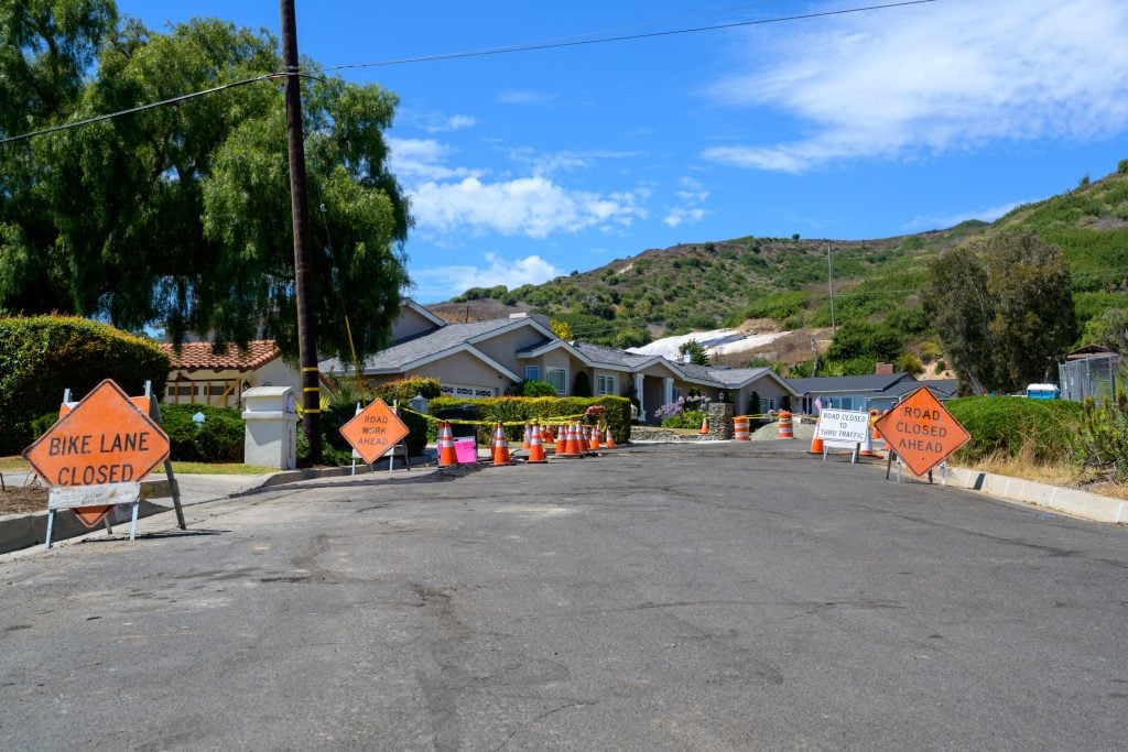
Status as of the date above, drawn from the City of Rancho Palos Verdes’ land movement updates through its September 15, 2026 report. This is a developing situation: the ground is still moving, the buyout program has not closed a purchase, and the Portuguese Bend community remains without grid electricity. The figures below are the city’s, and we replace them when the city does.
If you are reading this months from now, check the date against the city’s land movement page before relying on any number here.
The land in the Portuguese Bend area of Rancho Palos Verdes is moving more slowly than at any time since the fall of 2023. The city’s monitoring put the average across the active slide areas at just under one inch a week in September 2026, the first time it has fallen below that line in three years, and the Portuguese Bend landslide proper at about eight tenths of an inch a week, a 92 percent reduction from the rate before the deep dewatering wells went in. That is the good news, and it is real. The rest of the picture is that 715 acres remain under a permanent ban on new construction, roughly two dozen homes carry red or yellow tags, 27 properties have been selected for a federal buyout that has not yet bought anything, the community’s electricity has been off since 2024, and Palos Verdes Drive South is being regraded again ahead of a winter the forecasters expect to be wet. This is where things stand, what it means for the value of property across the Peninsula, and what a buyer or seller of a house near the slide should understand.
What is the Portuguese Bend landslide complex?
An ancient landslide on the south side of the Peninsula that reactivated in 1956, when road construction cut into it, and that has moved in some measure ever since. For most of the decades that followed, the movement was slow and the neighborhood lived with it: undulating roads, houses on adjustable foundations, utilities above ground, and two Geologic Hazard Abatement Districts, Abalone Cove and Klondike Canyon, formed by residents to run dewatering wells. The heavy rains of the 2022-23 and 2023-24 winters changed the scale. Groundwater rose, the slide accelerated by the city’s account to three to four times its prior rate, the affected footprint grew from about 380 acres to roughly 700, and homes in Portuguese Bend, Seaview and the Portuguese Bend Beach Club began to break. The city declared a local emergency in October 2023 and has extended it every 60 days since. Wayfarers Chapel, the Lloyd Wright glass chapel that stood on the edge of the slide since 1951, closed in February 2024 and was disassembled that summer to save it.
What are the numbers now?
| Measure | Status, per the city |
|---|---|
| Average movement, all active areas | 0.99 inches a week as of the September 15, 2026 update, down 9.8 percent since July and below one inch a week for the first time since October 2023 |
| Portuguese Bend landslide | 0.81 inches a week, a 92 percent reduction from the rate before deep dewatering; 74 percent of its footprint now moves less than an inch a week |
| Abalone Cove landslide | 1.29 inches a week, decelerating |
| Klondike Canyon | No measurable movement |
| Groundwater removed | More than half a billion gallons since the fall of 2024, through 22 Abalone Cove district wells and seven new wells, four of them city funded |
| Homes tagged | Thirteen red-tagged and nine to ten yellow-tagged as of the city’s mid-2025 counts, the most recent it has published |
| Buyout program | 85 eligible applications by November 8, 2024; 27 properties selected in two rounds; $42 million and $10.16 million in FEMA hazard mitigation grants sought for rounds one and two and $19 million for a third; no purchases closed as of September 2026 because the grants have not been formally awarded |
| Remediation | A $33 million dewatering project with a $23.3 million FEMA grant candidacy, and a broader $150 million remediation plan referenced in the September 2026 update |
| Ongoing city costs | About $53,000 a month for generators running the wells, $12,000 a month for the sewer system in the de-energized zone, and about $1 million a year resurfacing Palos Verdes Drive South |
| Electricity | The Portuguese Bend community remains de-energized by Southern California Edison; restoration is conditioned on sustained movement below one inch a week near the lines, and the city and the utility were meeting in September 2026 on a restoration plan |
| Gas | Restored to Seaview homes ready for service by October 2025; Beach Club and Rolling Hills work followed, all subject to reshutoff if movement increases |
| Palos Verdes Drive South | About 16,000 vehicles a day; a two mile stretch under recurring restrictions, with bicycles and motorcycles prohibited; winterization and regrading scheduled for completion by mid-October 2026 |
Two numbers on that table matter more than the rest. The first is the one inch a week line, because the utility has tied re-energization to it and because the dewatering results suggest the slide responds to groundwater in a way that can be managed. The second is zero, the number of buyout purchases completed two years after the program opened, which is the number that families in the tagged houses live with.
What can and cannot be built in the moratorium area?
Since September 18, 2025, when Ordinance 692 took effect, new residential construction has been permanently prohibited in the roughly 715 acre Greater Portuguese Bend Landslide Complex under Chapter 15.20 of the Rancho Palos Verdes Municipal Code, replacing the temporary urgency moratorium that had been in place since October 2023. The city’s summary of the regulations lists what is out: new houses, additions, new garages, most accessory structures, and new pools or pool replacement, with previously issued but unused permits revoked. What remains possible, through a Landslide Exception Permit, is repair and replacement within an existing footprint that does not increase lot coverage or water use, replacement of a house in the same general location where the hazard is not worsened, small storage structures without foundations, barns, limited grading, fences without retaining walls, geologic investigations, lot line adjustments and code upgrades to older structures. The 2025 ordinance added eight properties to the boundary, seven in Seaview and one in the Beach Club. A buyer of any parcel inside the line is buying a house that can be maintained and, within limits, rebuilt, and that cannot be expanded.
What does it mean for the rest of the Peninsula?
Less than the headlines suggest, and more than nothing. The landslide complex is a defined area on the south side of Rancho Palos Verdes; Palos Verdes Estates, Rolling Hills Estates, most of Rolling Hills and the great majority of Rancho Palos Verdes are outside it and on different geology. Values in Lunada Bay, Malaga Cove, the Rolling Hills gates and the Peninsula’s east side have not moved with the slide, and buyers there are not asked to price it. Where the slide reaches the wider market is in three places: insurance, where earth movement is excluded from standard homeowners policies everywhere and the Peninsula’s carriers have become more careful about hillside geology generally; disclosure, where every Peninsula seller now answers the geological questions on the Transfer Disclosure Statement with more care than a decade ago; and the road, because Palos Verdes Drive South is the route between the west side and San Pedro, and its restrictions are felt by everyone who drives it.
Inside and immediately around the complex, the market is thin and specific. Houses in Portuguese Bend, Seaview and the Beach Club trade, when they trade, to buyers who understand the moratorium, run on solar and batteries, accept that a mortgage may be unavailable and that a conventional insurer will not write the risk, and price the house as land they cannot build on. Some of those buyers are long-time residents buying neighbors’ houses. The rate of movement, if it keeps falling, will change that market before any other number does.
What must a seller disclose, and what should a buyer check?
The Transfer Disclosure Statement asks the seller directly about known landslides, settling and earth movement on or affecting the property, and a seller in or near the complex answers it in detail, attaching the city’s tagging notices, any geologic reports, the moratorium boundary and the utility status. The Natural Hazard Disclosure report covers the six statutory zones, and the state’s seismic hazard maps of earthquake-induced landslide zones appear on it, but the moratorium itself is a city ordinance and is disclosed as a material fact rather than through a statutory form. A buyer should obtain the geologic and geotechnical reports for the parcel, the city’s determination of whether the parcel is inside the moratorium boundary and which permits it has issued or revoked, the current utility status from Edison and the gas company, a written insurance quote before the contingency period ends, and the lender’s position, since many will not lend inside the line. We keep a current file of all of this for the affected neighborhoods, and we tell buyers what we do not know.
What happens next?
Three things are on the calendar. The winterization work on the road and the drainage improvements are scheduled to finish by mid-October, and the coming winter will test whether the dewatering holds when the rain returns; the city’s February 2026 update recorded a reacceleration after rainfall before the spring and summer slowdown. The FEMA grant awards for the buyouts, once they come, will let the city begin purchasing the 27 selected properties. And Edison’s decision on re-energization depends on the movement data staying below the line through the winter. Wayfarers Chapel, for its part, has identified a new site about a mile west at Battery Barnes beside City Hall and reported in August 2026 that it is advancing plans for a cultural campus there while fundraising continues. The original site remains closed.
We will update this page when one of those things happens. For the Peninsula’s other markets, our Rancho Palos Verdes, Palos Verdes Estates and Rolling Hills pages carry the current listings and the neighborhood detail, and our guide to the Rancho Palos Verdes view ordinance covers the rule that governs most of the rest of the city’s hillside property. If you own or are considering property near the complex and want a plain reading of where a specific parcel stands, send me the address.
Sources
- City of Rancho Palos Verdes: land movement information; 2026 community updates archive (entries through September 15, 2026); 2025 community updates archive; Voluntary Property Buyout Program; Landslide Area Development Regulations (Ordinance 692, Chapter 15.20); Portuguese Bend Landslide Remediation Project; Abalone Cove Landslide Abatement District; Klondike Canyon Landslide Abatement District; Financial Assistance Grant Program
- FEMA, Rancho Palos Verdes Portuguese Bend landslide case study
- Southern California Edison, Rancho Palos Verdes land movement updates; SoCalGas, Palos Verdes land movement
- Wayfarers Chapel (closure, disassembly and relocation updates)
Written October 2026 from the sources above as of the dates shown; the figures are the city’s and the utilities’ and change with each update. Insurance and lending availability are described generally and vary by carrier and lender. This article is general real estate information, not legal, insurance, lending or investment advice; a buyer or seller of property in or near the landslide complex should rely on the city’s current determinations, a geotechnical engineer and their own attorney.
Keep reading


