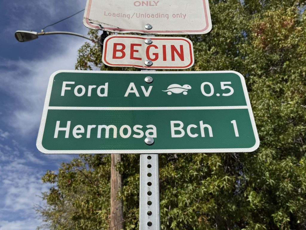
Updated October 15, 2026. Redondo Beach’s part of the South Bay Local Travel Network, the streets marked with rolling turtle signs and bike sharrows, launches Thursday, October 29, 2026, at 1 p.m. at Dominguez Park. The signs mark a recommended route for bikes, e-bikes, scooters, golf carts and neighborhood electric vehicles. They do not change what you can legally drive on those streets. State law lets a city open faster roads to neighborhood electric vehicles only by adopting a plan for them, and Redondo Beach has not adopted one.
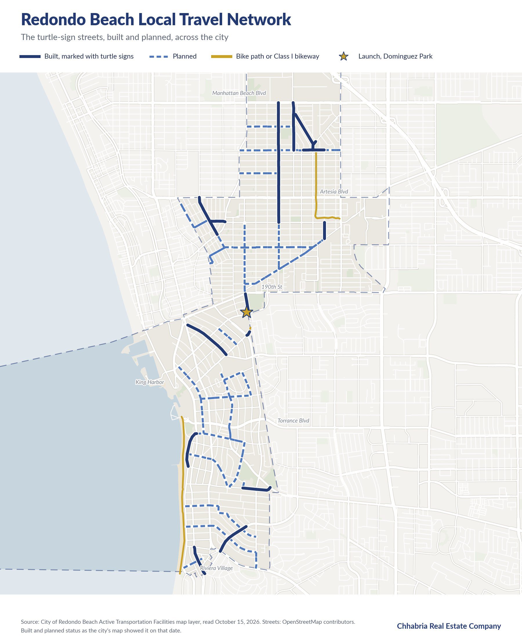
What is the Local Travel Network?
The South Bay Cities Council of Governments designed it as a network of existing low-speed streets for e-bikes, pedal bikes, e-scooters and neighborhood electric vehicles, planned to reach 243 miles across the South Bay. El Segundo’s routes opened first, in 2023. Redondo Beach is next.
The City of Redondo Beach calls its section a wayfinding system on lower-speed streets that cross major streets at traffic signals or stop signs and connect destinations around town. The city installed sharrows and wayfinding signs to guide riders without a phone in hand. The idea behind it is local trips: the Council of Governments’ research found about 70 percent of South Bay trips are three miles or less.
Which Redondo Beach streets are on the network?
The city’s own map layer labels each street as built or planned. As of October 15, 2026, it showed these, and the built list should grow as the city finishes the work it is launching on October 29. You can check any street on the city’s interactive Micromobility Network and Parking Map.
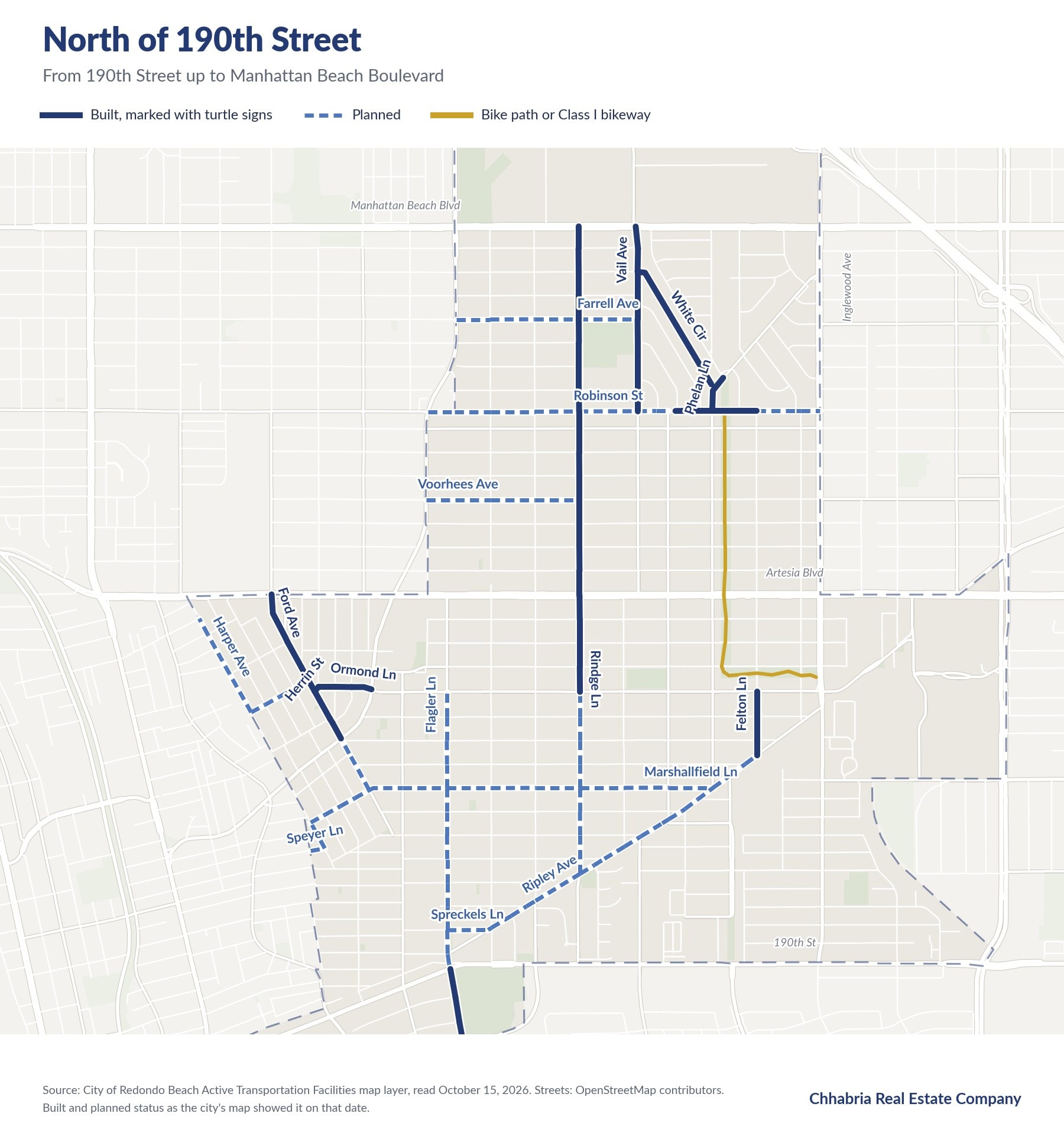
North of 190th Street
Built: Rindge Lane, Vail Avenue, White Circle, Phelan Lane, part of Robinson Street, Ford Avenue, Herrin Street, Ormond Lane and Felton Lane.
Planned: Farrell Avenue, more of Robinson Street, Voorhees Avenue, Marshallfield Lane, Ripley Avenue, Flagler Lane, Harper Avenue, Speyer Lane and Spreckels Lane.

undefined
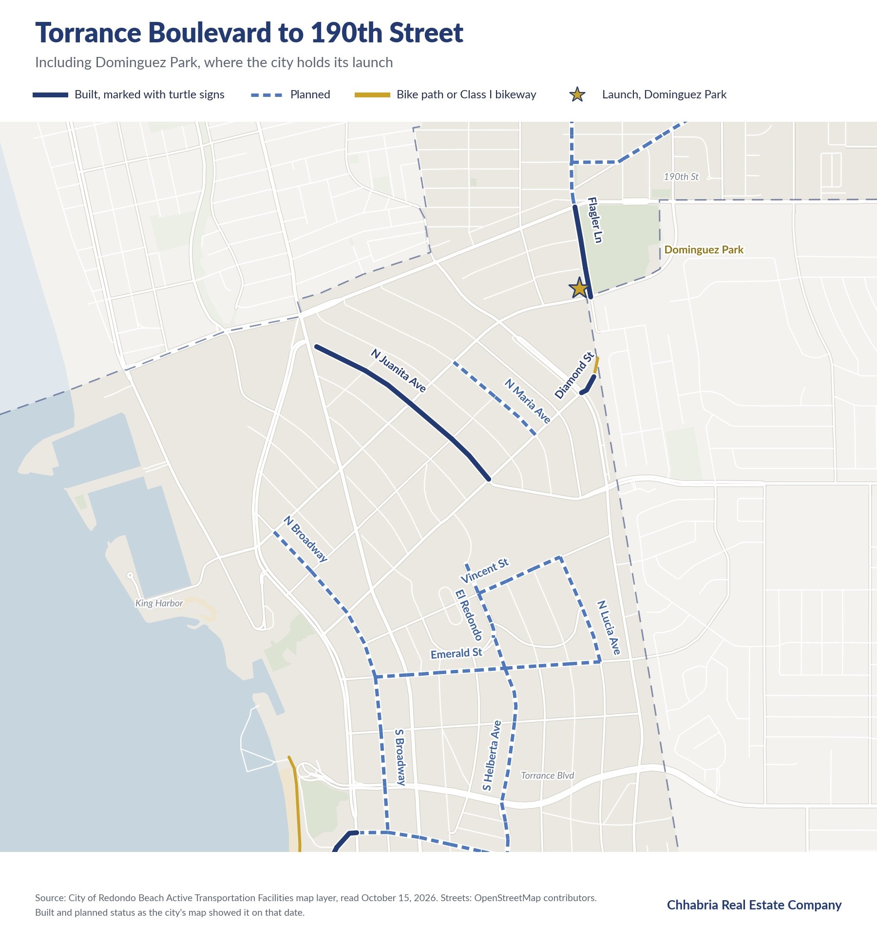
Torrance Boulevard to 190th Street
Built: Flagler Lane beside Dominguez Park, North Juanita Avenue and a short stretch of Diamond Street.
Planned: North Broadway, North Maria Avenue, Vincent Street, El Redondo, North Lucia Avenue, North Helberta Avenue and Emerald Street.
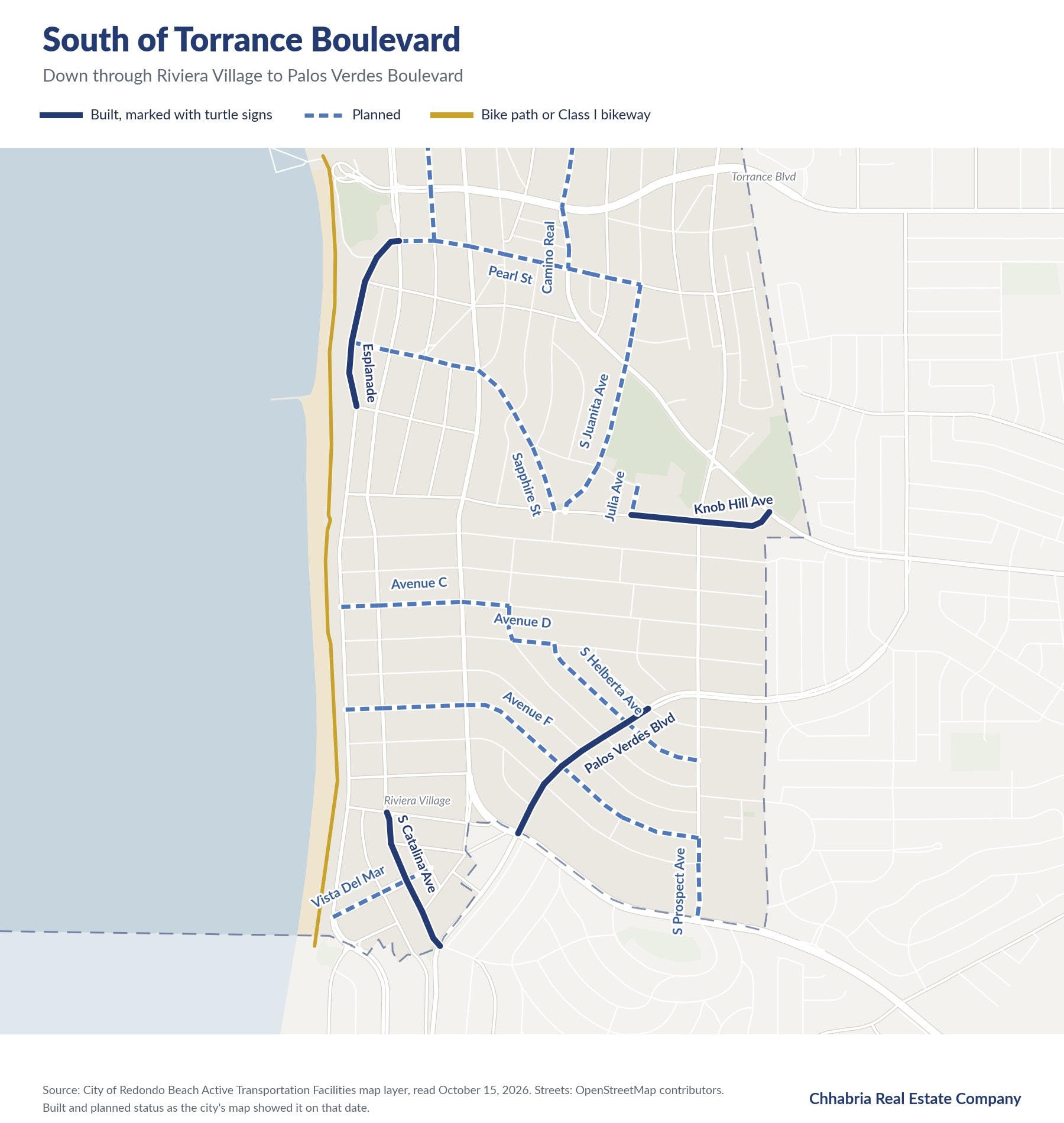
South of Torrance Boulevard
Built: Esplanade, Knob Hill Avenue, Palos Verdes Boulevard and South Catalina Avenue.
Planned: South Broadway, Pearl Street, Camino Real, South Juanita Avenue, Sapphire Street, Julia Avenue, Avenue C, Avenue D, Avenue F, South Helberta Avenue, South Prospect Avenue and Vista Del Mar.
When did Redondo Beach approve it?
The city says the City Council adopted it in 2025. The project came before the Council four times, according to the city’s Legistar records:
- September 6, 2022: a discussion of Bicycle Master Plan goals and Local Travel Network concepts.
- February 18, 2025: approval of the plans and specifications and a Measure M funding agreement, with authorization to put the project out to bid.
- December 9, 2025: a $1,156,882 change order with DASH Construction to build two projects, the first phase of the Grant Avenue resurfacing and the Local Travel Network.
- May 19, 2026: an amendment to the construction management and inspection contract covering several jobs, this one included.
Who paid for it?
Measure M, the Los Angeles County transportation sales tax, through the subregional program the Council of Governments manages. The line item, MM4601.16, “South Bay LTN in Redondo Beach,” carries $1,272,700 for design and construction, according to the agency’s Measure M program update. Redondo Beach owners paid into it the same way everyone in Los Angeles County does, at the register. For scale, Measure M is a half cent on the dollar, so $1,272,700 is what it collects on about $255 million of taxable sales.
What can you drive on a turtle-sign street?
- A neighborhood electric vehicle is the Vehicle Code’s low-speed vehicle: four wheels, a top speed of more than 20 and no more than 25 mph, and a weight rating under 3,000 pounds (Vehicle Code 385.5). It is a registered motor vehicle, so it needs plates, a licensed driver and insurance.
- Where it can go: no roadway with a speed limit over 35 mph unless a city has adopted a neighborhood electric vehicle plan. It may cross a faster road at an intersection where the roads on both sides are posted 35 mph or less, and crossing a state highway such as Pacific Coast Highway at an uncontrolled intersection needs approval from the agency that enforces traffic there (Vehicle Code 21260).
- A golf cart is a separate vehicle in the code, built for no more than 15 mph and two people (Vehicle Code 345). Driving one on a turtle-sign street does not make it a neighborhood electric vehicle, and its narrower rules still apply.
- E-bikes follow their own class rules. Our guide to South Bay e-bike laws covers them city by city.
A 2022 state law, AB 2432, lets Los Angeles County or any city in it adopt a neighborhood electric vehicle plan. A plan could open some faster routes and would also limit these vehicles to the routes on its map. Redondo Beach has not adopted one, so the 35 mph limit stands.
What do drivers need to know?
- The traffic laws for drivers did not change. What changed is how many bikes and low-speed vehicles are routed onto certain local streets.
- A sharrow is a shared lane marking. It does not create a bike lane or narrow the travel lane.
- Passing a bicycle, leave at least three feet. If there is another lane going your way, change lanes when you can. If you cannot, slow down and pass only when it will not endanger the rider. A violation carries a $35 fine (Vehicle Code 21760).
- A neighborhood electric vehicle tops out at 25 mph, so on a 35 mph street expect to come up behind one.
- The routes send riders across major streets at signals and stop signs, so expect more crossing traffic at those corners.
What does it mean if you own or are buying in Redondo Beach?
If you own on a signed street, expect more bikes and low-speed vehicles passing the house, most of them on short local trips. If you are buying, the city’s Micromobility Network and Parking Map, linked from its biking and micromobility page, shows which streets carry the route, so you can see how a house connects to Riviera Village, the pier and the K Line station by bike before you make an offer.
Where is the launch event?
Thursday, October 29, 2026, at 1 p.m. at Dominguez Park, 200 Flagler Lane, Redondo Beach. The city posts the event flyer on its biking and micromobility page.
For how the network fits with the bike paths, the K Line and the bus lines, see our guides to getting around the South Bay and cycling and bike paths in the South Bay.
Buying, selling, or still deciding if the South Bay is where you’ll settle down next? Neil Chhabria, Broker, 310.798.3122, neil@chhabriare.com.
Sources
Read October 15, 2026: City of Redondo Beach, Biking and Micromobility (route description, 2025 adoption, launch event); South Bay Cities Council of Governments, April 7, 2026 (network design, 243 miles, El Segundo 2023, 70 percent figure); South Bay Cities Council of Governments, Measure M program update approved September 2025 (line MM4601.16); City of Redondo Beach Legistar, files 22-4733, 25-0138, 25-1539 and 26-0522 (agenda dates and item titles); California Vehicle Code sections 345, 385.5, 21260 and 21760; AB 2432 (2022), chaptered text. Route streets and built or planned status: City of Redondo Beach Active Transportation Facilities map layer, behind the city’s Micromobility Network and Parking Map, read October 15, 2026; maps by Chhabria Real Estate Company with street data from OpenStreetMap contributors. Launch address from the City of Redondo Beach’s official Instagram.


